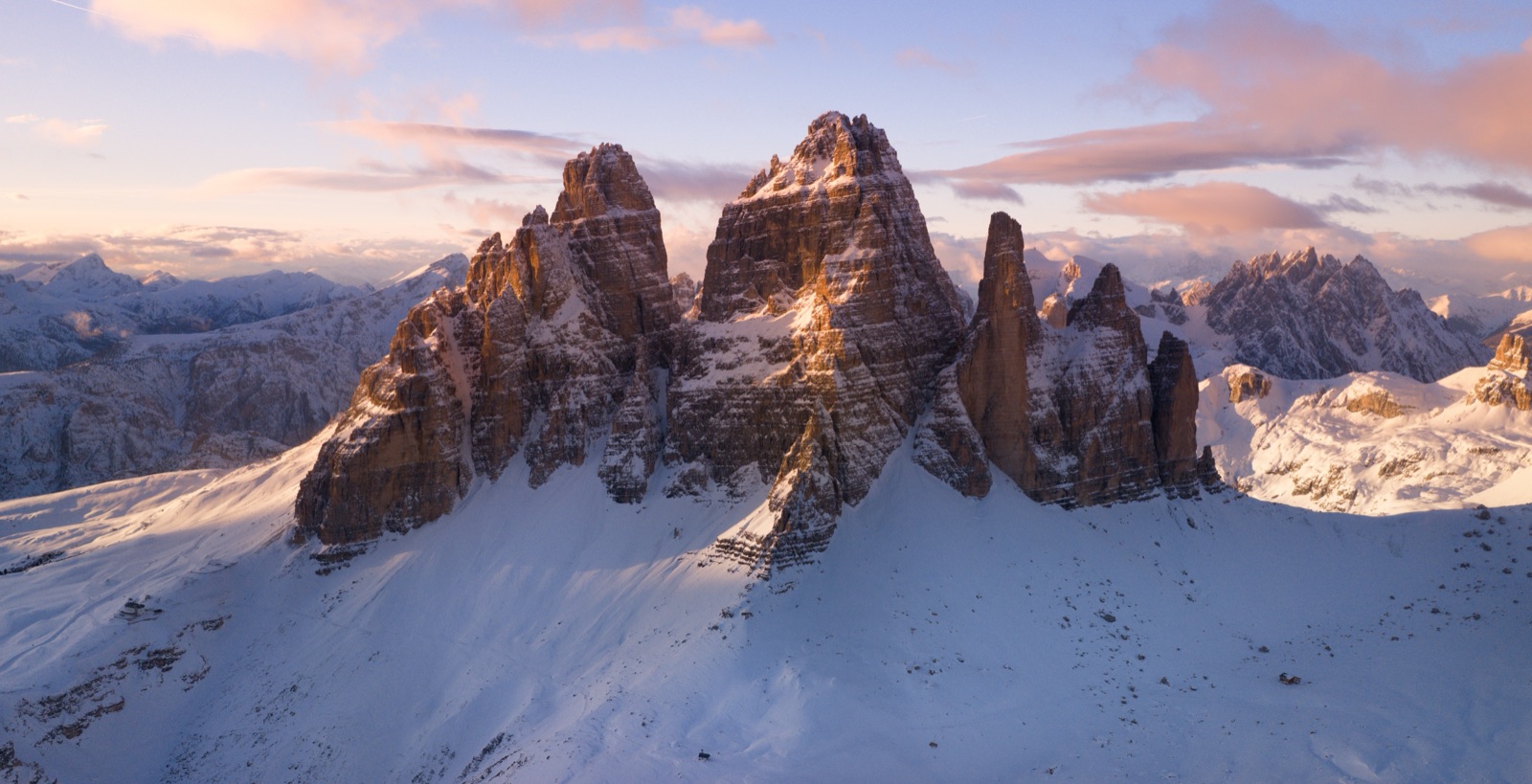
Monte Piana: The First World War Open-Air Museum Facing the Tre Cime
Monte Piana is the flat-topped mountain just north of Misurina, between Lake Misurina and Lake Landro, and it has one of the best views of the Tre Cime di Lavaredo in the Dolomites. It is also one of the saddest places in them: in the First World War the front line ran across its summit, and more than 14,000 soldiers died here. Today the plateau is an open-air museum of restored trenches, tunnels and positions. To visit, take the jeep shuttle from the Genzianella in Misurina to Rifugio Bosi (2,205 m) — in 2026 it ran every day from 1 June to 31 October, 9.00 to 17.00, at least every 20 minutes, with no booking, for €17 one way or €25 return — and then walk the paths across the plateau, which take 2½ to 4 hours depending on how much you want to see. You can also walk up, from Lake Antorno in about 2½ hours.
This guide covers getting there, the walk, the history, the view and how to combine Monte Piana with the Tre Cime in the same trip.
Monte Piana at a glance
- Height: 2,324 m at the south summit (Monte Piana); 2,320 m at the north summit (Monte Piano). The Hochpustertal tourist board and the jeep service give 2,325 m.
- Where: between the Tre Cime and Lake Misurina, above Lake Landro, on the border between the Veneto and South Tyrol.
- What: a First World War battlefield turned open-air museum, with a 360-degree view.
- Access: jeep shuttle from Misurina to Rifugio Bosi; or on foot from the road below, from Lake Antorno, from Landro or from Carbonin.
- Season: the jeep ran from 1 June to 31 October in 2026.
- Time needed: half a day with the jeep; a full day on foot.
Where it is
Monte Piana rises between the far north of the province of Belluno and South Tyrol, in the municipalities of Auronzo di Cadore and Dobbiaco. Its shape is unusual for the Dolomites: instead of spires and towers, it ends in a long, almost level plateau, almost two kilometres long and up to about 700 metres wide, cut off on every side by steep walls and cliffs. To the north it drops into the gorge of the Rienza, to the west it hangs directly over Lake Landro, and to the south and east it faces the Tre Cime and the Cadini.
The administrative border on the summit still follows the line that in 1753 separated the Republic of Venice from the Austrian Empire. That line is the key to everything that happened here.
The starting point for most visitors is Misurina, at 1,754 m, about 30 minutes by car from Cortina d’Ampezzo over Passo Tre Croci, or about 25 minutes from Dobbiaco. The old military road starts at Lake Misurina, 12 km from Cortina.
The war on Monte Piana
Italy declared war on Austria-Hungary on 24 May 1915. Because the border between the two countries ran straight across Monte Piana, both sides wanted to hold this strategically important mountain, which looks down on the roads from Cortina and Misurina to Dobbiaco.
On 7 June 1915 Austrian troops took Monte Piana and fortified it, despite Italian resistance. Shortly afterwards the Italians took its southern side. What followed was a bloody trench war that lasted two years and brought no decisive change: the two armies fought over a patch of ground on the plateau without ever overwhelming each other. The northern part, above Lake Landro, was the scene of furious fighting in an area not much bigger than a football pitch.
On 3 November 1917 the Italian units left their positions on Monte Piana to fall back to the Grappa line after the Austro-Hungarian breakthrough at Caporetto. By then, according to the jeep service and the tourist boards, more than 14,000 soldiers had died on the mountain.
Monte Piana and Monte Piano
The mountain has two names, and they record the two sides:
- Monte Piana is the southern summit, 2,324 m, held by the Italians.
- Monte Piano is the northern summit, 2,320 m, held by the Austrians — the name the Austrian sources used.
The two halves are joined by a hollow, the Forcella dei Castrati (2,201 m). Walking from one to the other, you cross what was no man’s land.
From battlefield to museum
After the war the mountain was left scattered with ruins and debris. In 1981 the open-air museum was handed to the Fondazione Monte Piana, and from 1983 a volunteer group, the Amici del Piana, has rebuilt the dry-stone walls that collapse every winter, restored shelters and wooden structures, cleared rubbish from the mountain and maintained the access paths. Today the museum is managed by several associations and the foundation.
Near the south summit stands the Piramide Carducci, a monument to the poet of the Ode to Cadore, destroyed in the war and rebuilt in 1923.
Getting there by jeep shuttle
The road to the top has been closed to traffic, bicycles included, since 1998. It is the old Italian military road, partly asphalted and in its upper part cut boldly into the rock, 6 km long with a climb of about 565 m. Because of its length and gradient, a jeep shuttle runs up it.
The 2026 service:
- Departure: Misurina, at the Genzianella bar-restaurant, Via Monte Piana 31.
- Arrival: Rifugio Bosi, at 2,205 m, just below the summit.
- Journey: the 5 km up take about 12 minutes.
- Dates: every day from 1 June to 31 October.
- Hours: 9.00 to 17.00.
- Frequency: continuous runs, at least every 20 minutes.
- Booking: not needed.
- Fares: €17 one way, €25 return, per person, sold at the departure point.
The Genzianella is also the starting point of the Dolomiti Bus shuttle to Rifugio Auronzo, so on a day without a car you can do both from the same stop.
Walking up
If you prefer to walk, several paths climb the mountain. They range from an easy hour to a demanding half-day.
- From the Misurina–Tre Cime road: following the military road, about 1 to 1½ hours with 450 m of ascent, on easy ground (Wikipedia).
- From Lake Antorno: about 2½ hours on foot, according to the Hochpustertal tourist board. There is a parking area in front of the lake.
- From Landro: a challenging ascent of about 4 hours according to the tourist board, or about 3 hours with about 900 m of ascent according to Wikipedia. The route follows the old Austrian military path, the Pionierweg, from the north shore of Lake Landro, up zigzags to the first Austrian barracks. About 200 m below the top, a junction offers the Colonnello Bilgeri via ferrata as an alternative to the military path, which continues to the old Austrian battalion command and up a stairway cut into the rock.
- From Carbonin: the Touristensteig, path 6, about 2½ hours with about 900 m of ascent; long and in places in poor condition, with a slightly exposed equipped section, so a via ferrata kit is advisable.
The Landro and Carbonin routes are for experienced walkers. For most visitors, the jeep up and a walk down, or the walk from Lake Antorno, is the right choice.
Rifugio Bosi and the Cappella degli Eroi
Rifugio Angelo Bosi is the only place to eat on Monte Piana. In 1962 Giovanni De Francesch bought a group of barracks that had housed the Italian command during the war and built the hut on the site. It is named after Major Angelo Bosi of the 55th Infantry, who was killed on the mountain in 1915.
Inside, a small private museum displays finds, photographs and documents from the war, and you can buy local guidebooks, books on the fighting and postcards. Beside the hut is the Cappella degli Eroi, the Heroes’ Chapel, dedicated to those who fell on Monte Piana.
The paths of the open-air museum start here, and they are for walkers only.
The open-air museum walk
There is no ticket and no gate: the museum is the mountain. From Rifugio Bosi, marked paths lead across the plateau to trenches, tunnels, gun positions, shelters, bomb craters and observation posts, many of them rebuilt by volunteers.
How long: the walk across the plateau takes 2½ to 4 hours, depending on how many of the historic sites you want to visit. The Hochpustertal tourist board describes the historic path as rather flat.
The main points:
- The south summit (Monte Piana). About 20 minutes from Rifugio Bosi: about 1 km and 120 m of ascent. The Capanna Carducci here is private and closed to the public; the Piramide Carducci stands nearby.
- The Forcella dei Castrati. The hollow between the two summits, the old no man’s land.
- The north summit (Monte Piano). The theme trail, path 122, climbs gently from Rifugio Bosi to the top of Monte Piano: 994 m, about 30 minutes, with 130 m of ascent and 17 m of descent.
- The northern edge. The Austrian positions above the cliffs and Lake Landro, with the densest network of trenches and tunnels.
Exposed sections. Some sites of the museum can be reached only across exposed but secured spots, with ropes or cables. These need sure-footedness, but the exposed parts can be avoided by using alternative paths.
On the ground:
- Stay on the paths. The plateau is pitted with craters and old trench lines.
- Take a head torch if you want to look into the tunnels.
- Do not remove anything. The finds belong to the museum and to the memory of the men who fought here.
The view
Monte Piana’s position gives it a 360-degree view over the mountains of Auronzo and Cortina: the Tre Cime di Lavaredo, the Paterno, the Cadini di Misurina, the Sorapiss, the Cristallo and the Croda Rossa, with Lake Misurina at its feet and Lake Landro far below on the other side.
The view of the Tre Cime is the reason many photographers come. From the plateau you see the three towers from the west, across the head of the Rienza valley, with the Paterno beside them — a different shape from the famous north-face view at Rifugio Locatelli and the south faces above Rifugio Auronzo. Our guide to Tre Cime viewpoints, sunrise and sunset compares the main viewpoints.
Remember that the jeep runs from 9.00 to 17.00. For early or late light you have to walk up and down.
A loop from Lake Antorno
For a full day on foot, a popular loop starts at the Lake Antorno car park, climbs to Rifugio Bosi, crosses both summits — Monte Piana and Monte Piano — and descends via Malga Rinbianco back to the lake. It involves about 670 m of ascent and descent and takes 4–5 hours of walking. It is easy in difficulty terms, but long, and the descent on the Rinbianco side is quieter than the jeep road.
Combining Monte Piana with the Tre Cime
Monte Piana and the Tre Cime are neighbours, and they fit well into the same trip.
On the same day:
- Morning on Monte Piana, afternoon at the Tre Cime. Take the first jeep at 9.00, walk the museum, come down by early afternoon, and take the Dolomiti Bus shuttle from the same Genzianella stop up to Rifugio Auronzo, or drive up if you have a parking slot for the afternoon.
- Early Tre Cime, afternoon Monte Piana. Start the Tre Cime loop at dawn, drive down to Misurina, and take the jeep in the afternoon. Remember that the Rifugio Auronzo ticket ends when you leave the car park.
On separate days: with two days in the area, give the Tre Cime one and Monte Piana, Lake Misurina and Lake Antorno the other. Our guide to Tre Cime parking explains why the car park at Lake Antorno makes the second day easy.
If you are visiting from Venice, Monte Piana is not on the standard day-trip routes, but the day trips listed on our tours page pass through Misurina and Cortina.
When to go
- Season: the jeep service ran from 1 June to 31 October in 2026. Early in the season, patches of snow can linger in the trenches and on the north side.
- Time of day: the first jeeps of the morning are the quietest, and the light on the Tre Cime is better before midday.
- Weather: the plateau is completely exposed. Avoid it in thunderstorms, and do not go up in low cloud if you want the view. The Tre Cime weather page shows what to expect month by month.
- Commemoration: a gathering in memory of those who fell on Monte Piana traditionally takes place on the first Sunday of September.
What to bring
The plateau is almost entirely rocky and completely without water sources, so carry what you need.
- Water and snacks, even if you plan to eat at Rifugio Bosi.
- Walking boots with good grip: the paths are rocky, with steps and some exposed sections.
- A warm, windproof layer. Above Rifugio Bosi, at 2,205 m, there is no shelter on the plateau.
- Sun protection. There is no shade.
- A head torch for the tunnels.
- Cash for the jeep, whose tickets are sold at the departure point.
With children
Monte Piana is a good outing for families with children who can walk a few hours. The jeep is an adventure in itself, the plateau is mostly level, and the trenches make the history real in a way no museum building can. Keep children close near the edges and the exposed sections, and take the alternative paths around them.
Frequently asked questions
How do you get to Monte Piana?
By the jeep shuttle from the Genzianella in Misurina to Rifugio Bosi, which takes about 12 minutes, or on foot from Lake Antorno in about 2½ hours. The road is closed to cars and bicycles.
How much is the Monte Piana jeep?
In 2026 it cost €17 one way and €25 return per person, with tickets sold at the departure point. No booking is needed.
How long does the Monte Piana open-air museum take?
The walk across the plateau takes 2½ to 4 hours, depending on how many sites you visit. The south summit is about 20 minutes from Rifugio Bosi.
Is Monte Piana difficult?
The museum paths are mostly flat, with some exposed but secured sections that can be avoided. The walks up from Landro and Carbonin are demanding.
Can you see the Tre Cime from Monte Piana?
Yes. The summit has a 360-degree view that includes the Tre Cime, Monte Paterno, the Cadini di Misurina, the Sorapiss and the Cristallo.
How many soldiers died on Monte Piana?
More than 14,000 soldiers died on the mountain during the First World War.