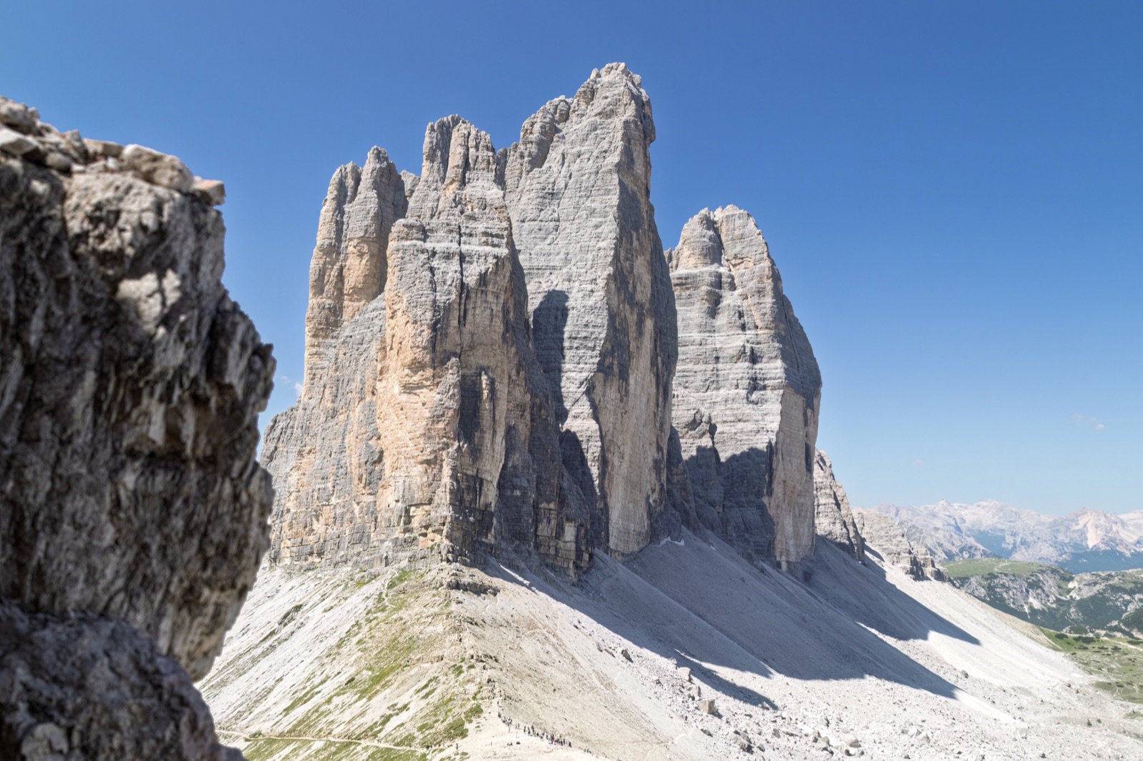
Hiking to the Tre Cime from the Valleys: Landro, Val Fiscalina, Val Campo di Dentro and Val Marzon
You do not need the toll road to reach the Tre Cime di Lavaredo. Several marked paths climb to the peaks from the surrounding valleys, and the local tourist board names three classic approaches from the South Tyrolean side: up the Rienza valley from Landro, through the Val Campo di Dentro (Innerfeldtal) from San Candido, and through the Fiscalina valley (Fischleintal) from Sesto. The shortest of them, from the Three Peaks viewpoint at Landro to Rifugio Locatelli, is 7.8 km with 973 m of ascent, about 3 hours 30 minutes; the longest takes 4 hours 30 minutes or more one way. From the south, a steep path climbs from Val Marzon above Auronzo. All of them are proper mountain walks, rated difficult, and all of them reward you with something the car park cannot: the peaks slowly growing in front of you as you climb.
This guide describes each route, where to park or catch the bus, how long it takes, and how to turn the walk into a one-way crossing with a bus back.
Why walk up instead of driving
The car park at Rifugio Auronzo needs an online booking and a fixed time, and it puts you on the busiest stretch of the Tre Cime loop with everyone else. Walking up from a valley is a different experience:
- No booking. The paths are free, and the valley car parks and buses need no reservation at the peaks.
- The approach is the point. On the Landro route, as the tourist board puts it, you see only the peaks at first and get closer and closer to them.
- Quieter paths. The valleys are busy near their car parks and then empty out as the path steepens.
- One-way crossings. You can walk up one valley and down another, or up from the north and down to the Dolomiti Bus at Rifugio Auronzo.
auronzo.info stresses that these routes are not simply shortcuts but proper mountain hikes, and that you should always check the difficulty, the time, the weather and how you will get back before setting off.
The routes at a glance
| Route | Start | Distance | Time | Ascent |
|---|---|---|---|---|
| Rienza valley to Rifugio Locatelli | Three Peaks view, Landro | 7.8 km one way | 3 h 30 min | 973 m |
| Val Campo di Dentro to the Tre Cime | Innerfeldtal, San Candido | 12.5 km one way | 4 h 30 min | 1,223 m |
| Fiscalina valley to Rifugio Locatelli | Fischleinboden, Sesto | — | 3½ hours one way (path 102) | — |
| Sextner Stein from the Fiscalina valley | Fischleinboden | 16.6 km return | 6 h 25 min | 1,071 m |
| Three-hut hike | Dolomitenhof, Fiscalina valley | 17.9 km loop | 6 h 30 min | 1,233 m |
| Val Marzon to Rifugio Auronzo | Cason della Crosera, Auronzo | — | 2 h 30 min to 4 hours | about 960 m |
Distances, times and heights for the first, second, fourth and fifth routes are from the 3 Zinnen Dolomites tourist board’s route pages; the Fiscalina time is the shuttle operator’s; the Val Marzon figures are from Rifugio Auronzo and auronzo.info, which differ. For comparison, the same tourist board gives the loop around the peaks from Rifugio Auronzo as 8.8 km and 4 hours, with 550 m of ascent.
From Landro up the Rienza valley
Start: the famous view of the Three Peaks at Landro, on the road south from Dobbiaco to Cortina, where parking places are available. Shuttle line 444 from Dobbiaco also passes near Lake Landro.
Finish: Rifugio Locatelli (the Dreizinnenhütte), at 2,405 m, facing the north faces.
The figures: 7.8 km, 3 hours 30 minutes, 973 m of ascent and 27 m of descent; highest point 2,348 m, lowest 1,403 m. Rated difficult.
The route. The walk begins where, for the first time, you see the north faces of the Three Peaks across the valley — one of the best-known views in the Dolomites. Path 102 heads east into the Rienza valley (Rienztal). After an easy start, the steeper part climbs in zigzags through mountain pines and up stone steps to the grassy basin of the Rienzboden. From there the gradient eases again, and the path leads up to the hut.
The tourist board describes it as a challenging alternative to the paths from Misurina and from the Fondovalle hut in Sesto. Wikipedia gives three hours from Lake Landro to Rifugio Locatelli.
Variation: from Lake Landro you can also take the Val Rinbianco on path 108 to Casera Rinbianco, and then follow the toll road or the path beside it to Rifugio Auronzo. From Malga Rin Bianco, trail 108A climbs to Forcella Col di Mezzo and reaches the north side of the peaks on an especially scenic route.
From the Val Campo di Dentro (Innerfeldtal)
Start: the Val Campo di Dentro, which opens on the right of the road between San Candido and Sesto. There is a car park at the entrance to the valley. The higher Antoniusstein car park can be reached by car only until 8.30 a.m. and after 6.00 p.m., and a traffic-light system controls the exit.
By bus: line 446 to the Innerfeldtal junction stop, or line 449 to Antoniusstein.
The figures: 12.5 km, 4 hours 30 minutes, 1,223 m of ascent and 85 m of descent; highest point 2,466 m, lowest 1,507 m. Rated difficult.
The route. The tourist board calls this a quite difficult but very beautiful hike through the middle of the Three Peaks nature park. The path to the peaks is entirely on Alta Via 4, and it ends at Rifugio Locatelli, with a stunning view of the north faces. The shuttle operator’s older listing gives 4½ hours from Val Campo di Dentro on path 105.
This is the longest of the three northern approaches and the quietest. It suits walkers who want a full day in the mountains and plan to sleep at the top or catch a bus down from Rifugio Auronzo.
From the Fiscalina valley (Fischleintal)
The Fiscalina valley above Sesto is only 4.5 km long, from the district of Moos to the hut at its head, and it runs into the heart of the Three Peaks nature park beneath the Sesto Sundial. It is one of the most celebrated valleys in the Dolomites and the start of several walks to the Tre Cime.
Parking and buses. The walks start at the Fischleinboden car park at the end of the valley road, which charges a fee. Coming from the Puster valley, turn off at San Candido into the Sesto valley; at the Restaurant Leone in Moos, turn into the Fischleintal and drive to the end of the road. By bus, take line 446 to the Fischleinboden stop, or in high season also line 440.
An easy start. Every route begins with the flat valley path to the Talschlusshütte (Rifugio Fondovalle) at 1,548 m, at the doors of the nature park. If you only want a walk in the valley, the tourist board’s route from Moos to the Talschlusshütte is 10.0 km and about 2 hours 35 minutes, with 197 m of ascent, and there is a buggy-friendly version from Sesto.
To Rifugio Locatelli on path 102
From the Talschlusshütte, path 102 turns right into the Altensteintal and climbs west to the Bödenalpe, with its small lakes, and on to Rifugio Locatelli. The shuttle operator gives about 3½ hours from Sesto on path 102. auronzo.info describes the route as demanding, with one of the most iconic views of the north faces at the top.
The Sextner Stein (Sasso di Sesto)
The tourist board’s suggested day out follows the same path to the Bödenalpe, passes below the Toblinger Knoten and makes the final climb to the Sextner Stein. At the top, the view opens directly onto the north faces of the Three Peaks, with the Paternkofel (Monte Paterno) rising beside them like a stone tower. You return the same way.
The figures: 16.6 km return, 6 hours 25 minutes, 1,071 m of ascent and 1,075 m of descent; highest point 2,543 m, lowest 1,449 m. Rated difficult, though the paths themselves are described as consistently easy hiking trails in alpine terrain.
The Three-hut hike
The finest long walk on the north side is the Three-hut hike, a loop around the Einserkofel that links three famous huts: the Zsigmondyhütte, the Büllelejochhütte (Pian di Cengia) and the Dreizinnenhütte (Locatelli).
The figures: 17.9 km, 6 hours 30 minutes, 1,233 m of ascent and descent. Rated difficult.
The route, as the tourist board describes it:
- Start at the Dolomitenhof car park (1,454 m), reached by bus, by car (parking fee) or in about 45 minutes on foot from Sesto.
- Follow the gentle path to the Talschlusshütte (1,548 m), then turn right onto trails 102/103 into the Altensteintal and climb briefly to a junction.
- Turn left on trail 103 and climb above the Bacherntal to the Zsigmondyhütte (2,235 m), with views of the Elferstock and the Zwölfer.
- From the hut, the high trail 101 leads west over stony, partly rocky ground to the Oberbachernjoch; keep right for the Büllelejochhütte (2,528 m), the highest point of the tour. A detour of about 30 minutes leads to the summit cross of the Oberbachernspitze.
- From the Büllelejoch (2,522 m) the path drops steeply across a scree field on the north side, then runs almost level with a view of the Dreischusterspitze to the Dreizinnenhütte (2,405 m) — one of the most spectacular views of the Three Peaks.
- Descend on trail 102 north-east across the Bödenalm and its two lakes, through the Altensteintal, back to the Talschlusshütte and the car park.
It is a long day, and many walkers split it with a night at one of the huts. Our guide to the Tre Cime huts has their beds, prices and booking dates.
From the south: Val Marzon
The southern approach starts in the Ansiei valley below Auronzo. Val Marzon opens on the right of the road to Misurina, about 6 km from the village of Auronzo. A road, asphalted for 5 km, leads to Cason della Crosera at 1,350 m; from there a tiring path climbs to Rifugio Auronzo.
The two local sources give different figures:
- Rifugio Auronzo gives path 1104, reaching the hut in 2 hours 30 minutes.
- auronzo.info describes the route as demanding, with about 960 m of ascent and a four-hour climb, through beautiful, less-frequented surroundings.
Rifugio Lavaredo gives a separate path from Val Marzon, path 104, reaching the hut in about 3 hours.
Allow the longer time. The value of Val Marzon is that it starts low, far from the crowds, and arrives at the south side of the peaks without any part of the toll road.
From Misurina and Lake Antorno
The simplest way to avoid driving the toll road is to walk it, or the paths beside it. From Misurina, Lake Antorno and the toll gate, marked trails lead up to Rifugio Auronzo. auronzo.info’s warning is about the car rather than the walk: pay attention to parking restrictions and use the marked car parks, such as the free one in front of Lake Antorno. Details are in our Tre Cime parking guide.
Through the Cadini: the Bonacossa
For experienced walkers with via ferrata equipment, the Alberto Bonacossa equipped trail crosses the Cadini di Misurina and leads to Rifugio Auronzo. It has many exposed sections fitted with cables, ladders and bridges, and calls for a helmet, harness and energy absorber. The full traverse takes about 5–6 hours. The first part, path 117 from Rifugio Auronzo to the Cadini viewpoint, is a much easier out-and-back walk.
One-way crossings and getting back
The great advantage of walking up is that you do not have to walk back the same way. Some combinations:
- Landro to Rifugio Auronzo. Up the Rienza valley to Rifugio Locatelli, round the peaks via Forcella Lavaredo, and down to the car park at Rifugio Auronzo, from where Rifugio Auronzo’s own access page gives 1 hour 30 minutes from Rifugio Locatelli via Rifugio Lavaredo on path 101. From Rifugio Auronzo, the Dolomiti Bus shuttle to Misurina runs from 7.30 to 20.00 (€10 per person for the day).
- Fiscalina valley to Rifugio Auronzo. Up path 102 to Rifugio Locatelli, then round to Rifugio Auronzo, and the bus down.
- Rifugio Auronzo to the Fiscalina valley. The reverse: shuttle or car up, a downhill finish to the Talschlusshütte and the bus from Fischleinboden.
- Val Campo di Dentro to Landro. Up Alta Via 4 to Rifugio Locatelli and down path 102 to Landro.
Check the last buses before you set out, and remember that if you drove to Rifugio Auronzo your car has to come down the same road.
When to go
Around Auronzo the best summer walking conditions are usually between late June and early September. Early in the season, check for lingering snow higher up, especially on north-facing slopes and scree. The high huts open only from mid- or late June — Rifugio Locatelli will open on 26 June 2027 — so a walk that relies on a hut for food or water should be planned inside its season.
September is often the clearest month, and the paths are quieter once the school holidays end. Our Tre Cime weather page shows what to expect in each month.
How hard are these walks?
All the valley routes on the tourist board’s list are rated difficult, not for technical climbing but for their length and height gain. Compared with the loop from Rifugio Auronzo, they involve roughly twice as much ascent or more.
- Fitness: expect 973 to 1,233 m of climbing on the main northern routes.
- Terrain: forest tracks low down, then stony paths, zigzags, stone steps and scree.
- Time: the published times are walking times. Add stops, photographs and the walk back or the bus.
- Weather: afternoon storms are common in summer. Start early, and turn back if the sky darkens.
What to bring
- Proper hiking boots with good grip.
- Water, a hat and sun protection: the upper sections have little shade.
- A waterproof, windproof jacket and a warm layer.
- Food, or money for the huts, and cash for the buses where cards are not accepted.
- A map, the bus times and a charged phone.
Sample plans
One long day from Dobbiaco. Drive or take the bus to the Three Peaks view at Landro, walk the Rienza valley to Rifugio Locatelli, continue round the north faces to Rifugio Auronzo, and take the bus or shuttle down.
A walker’s two days from Sesto. Day one: the Fiscalina valley, trail 103 to the Zsigmondyhütte and a night there. Day two: the high path past Pian di Cengia to Rifugio Locatelli, and down path 102 through the Altensteintal.
A quiet day from Auronzo. Val Marzon to Rifugio Auronzo, lunch, and the bus down via Misurina.
If you would rather not plan the logistics, the guided trips on our tours page include transport to the peaks.
Frequently asked questions
Can you hike to the Tre Cime without the toll road?
Yes. Marked paths climb from Landro through the Rienza valley, from San Candido through the Val Campo di Dentro, from Sesto through the Fiscalina valley, from Val Marzon above Auronzo, and from Misurina and Lake Antorno.
What is the shortest hike to the Tre Cime from the valley?
From the Three Peaks view at Landro to Rifugio Locatelli: 7.8 km and about 3 hours 30 minutes, with 973 m of ascent.
Where do you park for the Fiscalina valley walks?
At the Fischleinboden car park at the end of the valley road above Moos, which charges a fee. Buses 446 and, in high season, 440 stop there.
How long is the Three-hut hike?
17.9 km, about 6 hours 30 minutes, with 1,233 m of ascent and descent.
Are the valley routes difficult?
The tourist board rates them difficult because of their length and height gain. They are not technical, but they are full mountain days.